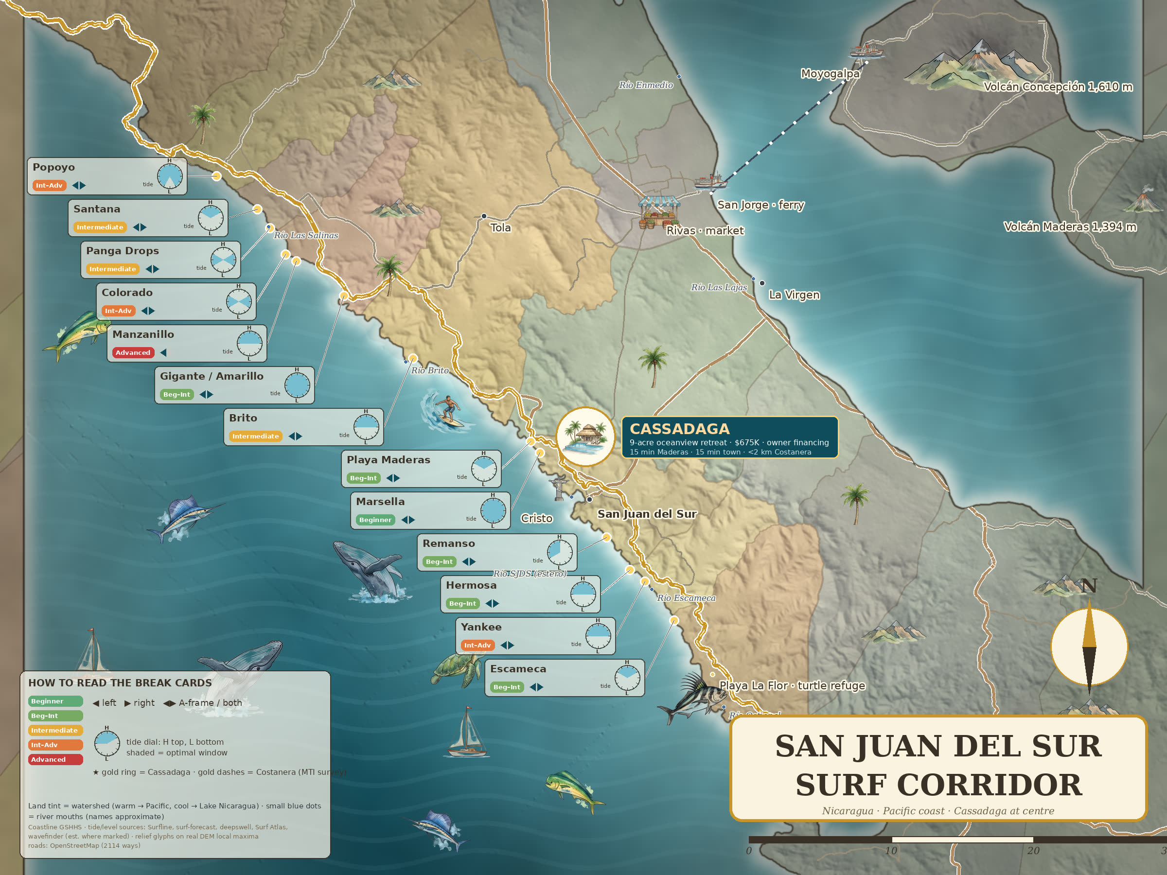
The corridor
This stretch of Nicaragua's Pacific coast runs from Popoyo in the north to Escameca in the south. Every house in the collection sits inside it, and every pin is placed from a real coordinate — four from the listings themselves, one from the seller's own record — rather than sketched onto the artwork.
Coordinates for each house come from its listing on investnicaragua.com, read 2026-08-23, except Prado Hills, which is placed from the seller's own record. Distances are straight-line — not drive times; the roads here rarely go straight.
| Nearest break | Straight line |
|---|---|
| Marsella | 3.5 km |
| Playa Maderas | 3.9 km |
| San Juan del Sur | 4.9 km |
| Nearest break | Straight line |
|---|---|
| Marsella | 1.2 km |
| Playa Maderas | 2.1 km |
| San Juan del Sur | 4.2 km |
| Nearest break | Straight line |
|---|---|
| Remanso | 3.0 km |
| San Juan del Sur | 3.1 km |
| Hermosa | 5.0 km |
| Nearest break | Straight line |
|---|---|
| Remanso | 2.9 km |
| Hermosa | 3.5 km |
| Yankee | 4.0 km |
| Nearest break | Straight line |
|---|---|
| Yankee | 4.2 km |
| Hermosa | 4.5 km |
| Remanso | 5.5 km |
| Nearest break | Straight line |
|---|---|
| Remanso | 2.2 km |
| San Juan del Sur | 2.7 km |
| Hermosa | 4.4 km |
North to south, with the coordinates the map is drawn from.
| Break | Coordinates |
|---|---|
| Popoyo | 11.4598, -86.1043 |
| Playa Santana / Colorado | 11.4315, -86.0764 |
| Panga Drops | 11.4139, -86.0660 |
| Manzanillo | 11.4066, -86.0467 |
| Playa Gigante / Amarillo | 11.3882, -86.0275 |
| Brito | 11.3437, -85.9812 |
| Playa Maderas | 11.2913, -85.9095 |
| Marsella | 11.2834, -85.9028 |
| San Juan del Sur | 11.2518, -85.8740 |
| Remanso | 11.2280, -85.8599 |
| Hermosa | 11.2065, -85.8446 |
| Yankee | 11.2004, -85.8364 |
| Escameca | 11.1738, -85.8165 |
Playa Maderas, Marsella, the bay at San Juan del Sur itself, Remanso, Hermosa and Yankee all sit within a short drive of every house on this page. The table beside each listing gives the three nearest breaks as a straight-line distance.
The corridor faces the Pacific and picks up swell all year. Nicaragua's offshore wind is the unusual part — the Lake Nicaragua gap pushes offshore breeze over this coast for a large part of the year, which is the reason the region has the reputation it does.
Popoyo sits at the northern end of this corridor and San Juan del Sur near the southern end — roughly 60 km apart in a straight line, and a good deal further by road. The map shows both ends of the same coast.
The full-size version, free — every break named, the tide window that works for each one, and the whole corridor on one sheet. Big enough to print.
Here it is. Download the map ↓
If you would rather just talk to somebody who surfs here, Christina is at the bottom of this page.
Wondering what this coast costs against Guanacaste? Costa Rica vs. Nicaragua →
Christina lives in San Juan del Sur and shows these herself. Tell her which one and she will send photographs, the deed position and what the closing actually costs.
Rather just message? WhatsApp +1 (361) 215-0088